The Weather Channel's Virtual Look At Potential Hurricane Florence Storm Surge Is Frightening
When a hurricane bears down on heavily populated coast areas, rain and high winds aren't the only major concerns. Hurricanes can push water very far inland into areas that normally never see water. One of the deadliest aspects of a hurricane approaching a populated area is the storm surge. Storm surge is when the hurricane pushes water well inland, and in the case of Hurricane Florence bearing down on the Carolinas, The Weather Channel is predicting that the storm surge could be 13-feet or more in some areas.
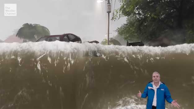
Meteorologists with The Weather Channel are predicting that storm surge flooding will easily reach 3-foot depths in many areas and some areas could go up to six feet or higher. The network has a new way to show people just how deep the surge will be. A new animation that The Weather Channel has cooked up is in the video below. The animation shows the meteorologist standing in a virtual yard surrounding by homes, trees, and cars. As the storm surge waters rise, you get an idea of how the storm surge will look compared to a normal man and how the surge will cover the environment in water. It's one of the best ways for people in these areas to visualize just how deadly the storm will be.
Hopefully, the video will show those thinking of ignoring the warnings to evacuate areas the storm will hit hardest to leave rather than risking their lives and the lives of rescuers trying to stay behind. A three-foot storm surge is more than anyone who chooses to stay behind will be able to walk or drive out of. It could make some cars flood out or even float away.
Watch out, America! #HurricaneFlorence is so enormous, we could only capture her with a super wide-angle lens from the @Space_Station, 400 km directly above the eye. Get prepared on the East Coast, this is a no-kidding nightmare coming for you. #Horizons pic.twitter.com/ovZozsncfh
— Alexander Gerst (@Astro_Alex) September 12, 2018
The tweet above has images taken by astronaut Alexander Gerst from the ISS. This image gives you an idea just how massive Hurricane Florence is. Gerst had to use a wide-angle lens to be able to get the entire storm in the frame, even though the ISS is orbiting some 400km above the surface of the Earth.